


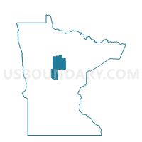
Turtle Lake Twp. Voting District, Cass County, Minnesota
About
Outline

Summary
| Unique Area Identifier | 601435 |
| Name | Turtle Lake Twp. Voting District |
| County | Cass County |
| State | Minnesota |
| Area (square miles) | 71.97 |
| Land Area (square miles) | 48.71 |
| Water Area (square miles) | 23.25 |
| % of Land Area | 67.69 |
| % of Water Area | 32.31 |
| Latitude of the Internal Point | 47.07155160 |
| Longtitude of the Internal Point | -94.47851260 |
Maps


Graphs
Select a template below for downloading or customizing gragh for Turtle Lake Twp. Voting District, Cass County, Minnesota


Neighbors
Neighoring Voting District (by Name) Neighboring Voting District on the Map
- Birch Lake Twp. Voting District, Cass County, MN
- Hiram Twp. Voting District, Cass County, MN
- Leech Lake Twp. Voting District, Cass County, MN
- Pine Lake Twp. Voting District, Cass County, MN
- Rogers Point Voting District, Cass County, MN
- Shingobee Twp. P-1, Cass County, MN
- Shingobee Twp. P-2, Cass County, MN
Top 10 Neighboring County Subdivision (by Population) Neighboring County Subdivision on the Map
- Shingobee township, Cass County, MN (1,514)
- Turtle Lake township, Cass County, MN (683)
- Birch Lake township, Cass County, MN (524)
- Leech Lake township, Cass County, MN (436)
- Hiram township, Cass County, MN (316)
- Pine Lake township, Cass County, MN (207)
- North Central Cass UT, Cass County, MN (28)